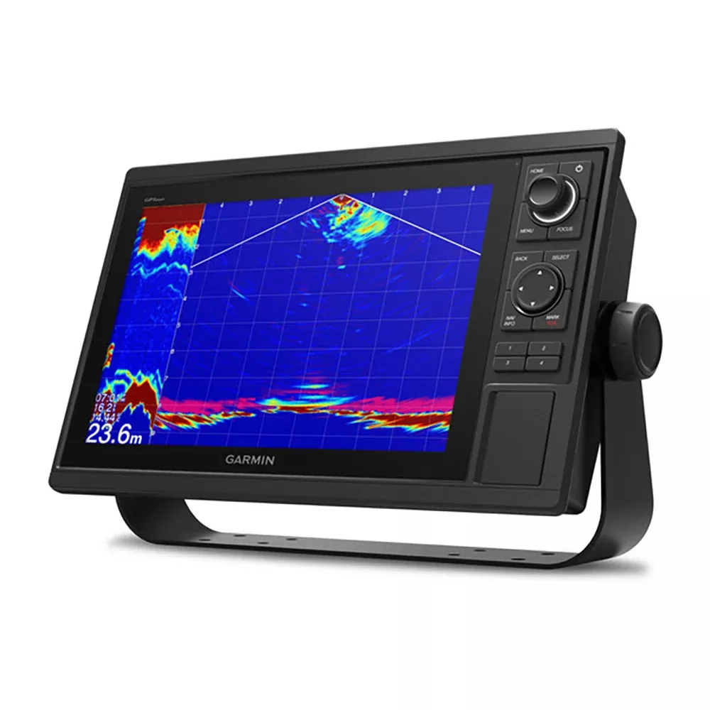
The Garmin GPSMAP 1222 (MPN 010-01741-00) is the 12-inch keyed (physical-button, non-touchscreen) chartplotter from Garmin’s GPSMAP networking line – designed specifically for cruisers, sailors, and sailing racers who prefer the tactile certainty of physical buttons over touchscreen operation, especially in wet conditions or rough water where touchscreens become hard to use accurately. Large 12-inch color display with the keypad interface and multifunction control knob that’s the GPSMAP series signature. NO built-in sonar (this is a chartplotter-only variant – for combined chartplotter and sonar, the GPSMAP xsv variants add sonar capability). High-sensitivity internal 10 Hz GPS and GLONASS receiver delivers position fixes 10 times per second for fluid on-screen movement. Full network capability: Garmin Marine Network (sonar / radar / camera sharing across multiple chartplotters), NMEA 2000 (modern boat instrumentation network), and NMEA 0183 (legacy device support). Built-in Wi-Fi for the ActiveCaptain app integration with mobile devices. Built-in ANT wireless connectivity to compatible Garmin marine watches, in-view displays, wind transducers, and wireless remotes. Two SD card slots for chart upgrades. Built-in SailAssist features including pre-race guidance, virtual starting line, laylines, and race timer. Includes power/data cable, NMEA 2000 T-connector and 2m drop cable, bail mount kit, flush mount kit with gasket, protective cover, trim piece snap covers.
The Garmin GPSMAP 1222 is the 12-inch keyed-interface chartplotter in the GPSMAP networking line – the right call for cruisers, sailors, and offshore boaters who want a serious mid-large chartplotter with physical button controls rather than the touchscreen interface that dominates current Garmin offerings. The keyed interface is genuinely better than touchscreens for specific use cases: operating with wet hands or wet display surface, operating in rough water where you can’t reliably tap a specific spot on a touchscreen, operating with gloves on in cold weather, and operating without taking your eyes off the water (the physical buttons are tactile – you can feel the right button without looking).
12-inch color display. The 12-inch screen is the mid-large size in the GPSMAP line, sized for serious helm installations where the chartplotter is the primary navigation reference. 12 inches gives you enough screen real estate for full chart display without cramping, multi-pane displays (chart + radar split, chart + instruments split), and detailed display of navigation data fields. For tighter helms with limited dash space, the 10-inch GPSMAP 1022 (the matching keyed model in the same line) is the right alternative.
Keypad interface and multifunction control knob. The user interface combines physical buttons (keypad with dedicated function keys plus user-programmable keys) and a multifunction rotary control knob for navigation through menus and lists. The keypad / knob interface is fast for users who learn it – dedicated keys for common functions mean one-button access without menu diving, and the knob’s rotational input is excellent for scrolling through long lists or precisely zooming charts. For cruisers and sailors who use the chartplotter daily, the keyed interface becomes muscle memory faster than learning touchscreen gesture conventions.
NO built-in sonar – chartplotter only. The 010-01741-00 variant is specifically the chartplotter-only model with no built-in sonar. This is the right choice for sailboats and cruisers where you have a separate dedicated sonar system (or no need for sonar) and you want to avoid paying for sonar functionality you won’t use. For owners who need combined chartplotter + sonar in one unit, the GPSMAP 1222xsv variants add CHIRP sonar capability at higher cost. Verify your need – if you might want sonar later, the xsv version is the right call now to avoid replacement.
10 Hz GPS / GLONASS receiver. The internal high-sensitivity receiver tracks both GPS satellites (US system) and GLONASS satellites (Russian system, more satellites visible globally) and delivers position fixes 10 times per second. The 10 Hz refresh rate vs the 1 Hz typical of older chartplotters means smooth on-screen movement at speed – at 30 knots, 10 Hz gives you a position update every 5 feet of travel vs 50 feet for 1 Hz. For sailing applications where the boat speed is lower (5-15 knots typical), the 10 Hz rate gives you smooth tracking even in tacks and other quick maneuvers.
5,000 waypoint capacity. Internal storage holds up to 5,000 waypoints – sufficient for serious cruising owners who accumulate waypoints over years of voyaging. Combined with route storage and track history, the storage handles typical cruising data needs without external memory cards. For owners who eventually exceed the internal storage, the SD card slots support expanded data storage.
Garmin Marine Network. The chartplotter connects via Garmin’s proprietary Marine Network for sharing data with other compatible Garmin equipment: external sonar modules, radar (dome or open-array), IP cameras, Panoptix sonar, and other GPSMAP chartplotters at additional helm locations. The Marine Network is what makes the GPSMAP series work as a integrated multi-helm electronics system rather than just a standalone chartplotter. For boats with multiple helms or planning to expand the electronics package over time, the network capability is essential.
NMEA 2000 and NMEA 0183 support. NMEA 2000 is the modern boat electronics network standard – integrates engine instruments, autopilots, wind / depth / speed sensors, AIS receivers, VHF radios, FUSION-Link audio systems, and digital switching systems with the chartplotter. NMEA 0183 is the legacy serial protocol still used by some older equipment and some specialized devices (older AIS units, some wind instruments, some autopilots). The GPSMAP 1222 supports both protocols, which means it integrates with virtually any current or legacy marine electronics on a typical boat.
Built-in Wi-Fi and ActiveCaptain app. Built-in Wi-Fi connects the chartplotter to mobile devices running Garmin’s ActiveCaptain app. ActiveCaptain features: cartography sync between chartplotter and mobile device (plan trips on phone, sync to chartplotter), purchase new charts directly through the app, access to Garmin Quickdraw Contours Community (user-contributed bathymetric data), smart notifications from the phone displayed on the chartplotter screen, and software update management. For owners who use mobile devices for trip planning before launching, ActiveCaptain is meaningful workflow improvement.
Built-in ANT wireless connectivity. ANT is the wireless protocol Garmin uses for low-power short-range device-to-device communication – separate from Wi-Fi and Bluetooth. The GPSMAP 1222 includes ANT for direct wireless connection to: quatix marine smartwatches (chartplotter data on your wrist), Garmin Nautix in-view display (overhead heads-up display projecting navigation data), gWind Wireless 2 transducer (wireless wind data without running data cables up the mast), GNX Wind marine instrument, and Garmin wireless remote controls.
SailAssist features. The chartplotter includes built-in features specifically for sailing: pre-race guidance page with virtual starting line and data fields showing laylines, time-to-burn before start, and a race timer that synchronizes across all networked Garmin GPS products. Plus: enhanced wind rose, heading and course-over-ground line display, set and drift calculation, true and apparent wind data display, and other sailing-specific data presentations. For sailing racers, these features turn the chartplotter into a serious race-management tool.
BlueChart g2 Vision HD compatibility. The chartplotter supports optional BlueChart g2 Vision HD chart upgrades – the premium Garmin coastal cartography that includes Auto Guidance (Garmin’s automated route-finding feature that calculates routes around hazards based on your vessel parameters and the chart data), high-resolution coastal imagery, fishing chart layers, and other premium navigation features. For owners cruising specific coastal regions where the premium chart capabilities matter, the BlueChart g2 Vision HD upgrade is the right call.
Two SD card slots. The chartplotter has two SD card slots that accept Garmin chart cards (LakeV HD inland charts, BlueChart g2 HD coastal charts, or BlueChart g2 Vision HD premium coastal). Two slots let you keep two chart sets active simultaneously – typical use is one card for the home cruising area and one for occasional travel cruising regions. Cards swap easily for different cruising plans.
GPX waypoint transfer. If you have waypoints, tracks, or routes stored on another manufacturer’s GPS product or on a Garmin handheld device, you can transfer them to the GPSMAP 1222 via the industry-standard GPX format. Useful when upgrading from older chartplotters or when consolidating navigation data from multiple sources onto one current device.
Connections. The GPSMAP 1222 includes 2 Garmin Marine Network ports (for connecting to other Marine Network devices and chartplotters), 1 NMEA 2000 port (with the included T-connector and 2m drop cable for connecting to the boat’s NMEA 2000 backbone), 1 NMEA 0183 input port and 1 NMEA 0183 output port (for legacy device integration), 1 BNC video input port (for connecting cameras with composite video output), and built-in wireless (Wi-Fi and ANT). No video output port (the chartplotter doesn’t drive external displays – use a Marine Network slave display if you need an external screen).
What’s in the box. The kit ships with the GPSMAP 1222 chartplotter unit, the power / data cable, an NMEA 2000 T-connector, a 2-meter NMEA 2000 drop cable, the bail mount kit with knobs (for surface mounting), the flush mount kit with gasket (for flush-into-dash mounting), a protective cover for the display when not in use, trim piece snap covers, and the documentation. Both mount kits included means you decide at install time which mount style is right for your specific helm layout.
Install. Choose surface mount (using the bail mount kit) or flush mount (using the flush mount kit with the gasket). Mount the chartplotter at the helm using the chosen mount kit. Connect 12V power via the supplied power / data cable through an appropriate fuse (typical 5-7A fuse for the chartplotter). Connect the NMEA 2000 T-connector to your boat’s existing NMEA 2000 backbone (or create a backbone if the boat doesn’t have one). Connect optional NMEA 0183 devices, video cameras, Marine Network devices as needed. Configure chartplotter settings on first boot. Total install runs 2-4 hours for someone with reasonable mechanical and marine electrical skills.