Embark on your next outdoor quest with confidence, armed with the precision of Garmin’s TOPO US 24K Northeast maps. Designed for adventurers who demand accuracy in every step, these maps deliver a level of detail that rivals traditional paper charts, helping you navigate rugged terrains, discover hidden gems, and plan routes that match your skill level. Whether you’re scaling summits in the Appalachians or tracing trails through the Great Lakes region, this microSD/SD card unlocks a world of topographic richness right on your compatible Garmin device.
Expansive Coverage Across the Northeast and Midwest
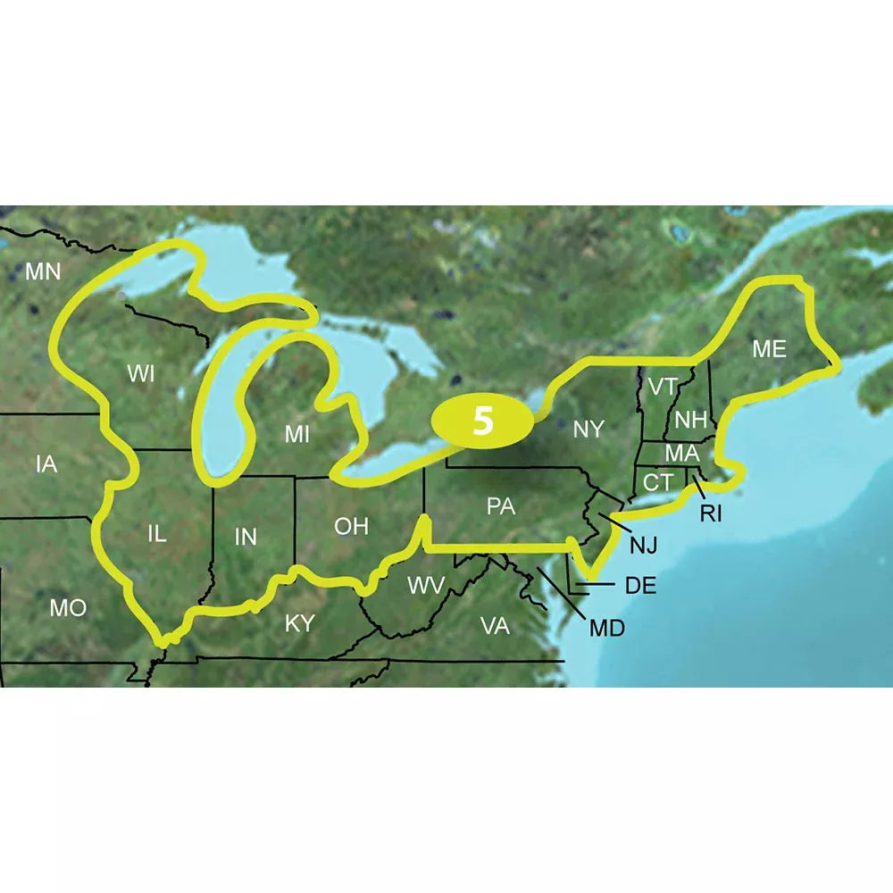
Spanning a vast area perfect for regional explorers, these maps cover key states including Connecticut, Illinois, Indiana, Maine, Massachusetts, Michigan, New Hampshire, New Jersey, New York, Ohio, Pennsylvania, Rhode Island, Vermont, and Wisconsin. From coastal shorelines along the Atlantic to inland forests and waterways, you’ll have comprehensive data for urban escapes, backcountry hikes, and everything in between. The 24K scale ensures fine-grained details like subtle elevation changes and narrow paths that coarser maps often miss.
Standout Features for Serious Outdoor Pursuits
Ultra-Detailed Topography: Terrain contours, elevations, and summits mirror 1:24,000-scale USGS maps, giving you a bird’s-eye view of the landscape.
Hydrographic Precision: Spot coastlines, lake and river shorelines, wetlands, and streams—perennial or seasonal—for safe water crossings and fishing spots.
Smart Search Tools: Quickly find cities, summits, lakes, campsites, and more with intuitive point-of-interest queries.
Elevation Insights: Generate profiles on supported devices to gauge climb difficulty and prepare for the challenge ahead.
Routable Networks: Navigate via trails, rural roads, neighborhood streets, highways, and interstates with turn-by-turn guidance where available.
Natural and Recreational Highlights: Locate national, state, and local parks, forests, conservation areas, wilderness zones, campgrounds, scenic lookouts, and picnic areas.
Land Management Data: Access Bureau of Land Management township, range, section grids, plus USGS quad boundaries for precise public land navigation.
Why These Maps Elevate Your Adventures
Imagine plotting a multi-day backpacking trip through the Adirondacks or a mountain bike loop in the Poconos—these maps make it seamless. The 3D terrain shading on compatible units brings the landscape to life, helping visualize ridges and valleys before you hit the trail. Hunters appreciate the secluded spots marked by detailed hydro features, while kayakers rely on accurate shorelines. Even off-road enthusiasts find value in routable backroads leading to remote fishing holes. Paired with Garmin’s ecosystem, updates keep your data fresh, though note that refresh requires a new card purchase.
Seamless Compatibility and Setup
Built for Garmin chart plotters and GPS navigation systems with a microSD/SD slot, this package includes both card formats for versatility. Pop it into your device for instant access, or use BaseCamp or HomePort software on a computer for planning. Always verify your model’s compatibility first to ensure smooth integration—some marine units have specific limitations. The rugged card design withstands the elements, so it’s ready for your pack or boat.
Real-World Tips from Seasoned Users
For best results, layer these topo maps with your device’s satellite imagery for hybrid views that blend man-made paths with natural features. Practice elevation profiling during route planning to avoid surprises on steep ascents. In dense forests like Michigan’s Upper Peninsula, the trail routability shines, often revealing lesser-known paths overlooked by apps. Combine with a handheld GPS for battery-efficient, screen-independent navigation on long hauls.
Frequently Asked Questions
What states are covered by Garmin TOPO US 24K Northeast?
The maps include detailed coverage of Connecticut, Illinois, Indiana, Maine, Massachusetts, Michigan, New Hampshire, New Jersey, New York, Ohio, Pennsylvania, Rhode Island, Vermont, and Wisconsin.