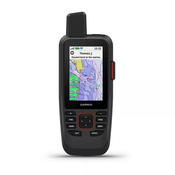
Imagine heading out on your next fishing trip or coastal cruise, equipped with a rugged companion that not only charts your course but keeps you connected when you’re far from shore. The GPSMAP 86sci stands out as a versatile marine handheld, blending precise navigation, satellite messaging, and seamless boat integration into one floating powerhouse. Its 3-inch sunlight-readable color display ensures you spot critical details even under the harshest glare, while button controls keep operations glove-friendly during choppy conditions.
Crafted for boaters who demand reliability, this device smooths out erratic GPS readings from boat motion with an adjustable filter, delivering steadier speed and heading data. Whether dodging shallows or plotting a multi-stop itinerary, the preloaded BlueChart g3 coastal charts reveal intricate 1-foot contours, revealing hidden structures that could make or break your day on the water.
Seamless Connectivity to Elevate Your Onboard Experience
Go beyond standalone navigation by linking the GPSMAP 86sci to your vessel’s chartplotter or instruments. Stream live data like engine stats, wind speeds, or depth readings directly to the handheld for a unified view—no more glancing between screens. It even doubles as a remote for Garmin autopilots and select audio systems, letting you tweak course or volume without leaving the helm.
Wireless options abound: Bluetooth pairs effortlessly with your phone for smart notifications, Wi-Fi handles quick updates, and ANT+ connects to sensors. Sync everything to the Garmin Explore platform to backup waypoints, routes, and tracks in the cloud, so your hard-earned data travels with you across devices.
Stay Connected Off the Grid with inReach Technology
In remote bays or open ocean, where cell towers are a distant memory, inReach satellite tech shines. Exchange texts with family ashore, share your position with crew, or summon help via interactive SOS through the global Iridium network. Pull in weather overlays tailored for marine forecasts, helping you skirt storms or time your return just right.
A built-in LED flashlight adds practicality, switching to strobe mode for signaling in low light. Pair that with a barometric altimeter for elevation changes and a 3-axis compass for rock-solid heading, and you’ve got tools for adventures beyond the coast—hiking coastal trails or exploring inlets on foot.
Built Tough for Endless Horizons
This isn’t just a GPS; it’s adventure-ready gear. IPX7 waterproofing means it survives submersion and bobs back to the surface if dropped overboard. Rechargeable lithium battery pushes up to 35 hours in tracking mode or 200 hours in expedition mode, outlasting even the longest outings. Store 10,000 waypoints, with room for more via microSD, including BirdsEye satellite imagery for visual context.
Keyed interface resists accidental inputs, and high-speed USB ensures fast charging and data transfer. From the lanyard for secure handling to the powered mount for dash setup, every detail prioritizes real-world boating needs.
Unlock Peak Performance On and Off the Water
Boaters rave about how the GPSMAP 86sci transforms routine trips into stress-free ventures. Custom routes with marine-specific guidance avoid no-go zones, while lifetime map updates keep your charts current without hassle. Integrate NMEA 0183 for broader compatibility, and leverage the worldwide basemap for planning ventures far from U.S. coasts.
Pro tip: Activate the GPS filter during rough seas for pinpoint accuracy, and use the flashlight beacon during night maneuvers. It’s the backup navigator that becomes your primary ally when systems falter.
Ready-to-Launch Kit
GPSMAP 86sci handheld preloaded with U.S. BlueChart g3 coastal charts
Powered mount for secure installation
Lanyard for hands-free security
USB to Micro USB cable for charging and syncing
USB to 2-pin cable for alternative power
Mounting hardware for custom setups
Comprehensive documentation to get you started
Frequently Asked Questions
Does the GPSMAP 86sci float if dropped in water?
Yes, its buoyant design ensures it floats to the surface, combined with IPX7 waterproofing for submersion up to 1 meter for 30 minutes.
What kind of battery life can I expect?
Up to 35 hours in 10-minute tracking mode or 200 hours in expedition mode, depending on usage; the user-replaceable lithium battery supports extended trips.
Are satellite messaging features free?
inReach satellite communication requires an active subscription for two-way texting, tracking, and SOS functionality via the Iridium network.
What charts are preloaded on this device?
BlueChart g3 coastal charts for the U.S., featuring detailed 1-foot contours, Garmin and Navionics data integration, plus a worldwide basemap.
Can it connect to my boat’s chartplotter?
Absolutely, it streams boat data wirelessly and serves as a remote control for compatible Garmin chartplotters, autopilots, and instruments.
Is the display readable in direct sunlight?
Yes, the 3-inch TFT color display with 240×400 resolution is optimized for sunlight readability, perfect for open-water use.
Does it support map expansions?
Yes, via microSD card slot for additional maps, BirdsEye satellite imagery, and custom data storage.